What AIS manipulation actually costs
A falsified vessel position is cheap to create and expensive to believe. That asymmetry is the problem. A commercial spoofer costs a few hundred dollars. The cost of acting on the picture it corrupts falls on whoever tasked the aircraft, ordered the boarding, cleared the port call or signed off the sanctions screen.
Most discussion of AIS manipulation stops at the safety case. For defence and security users, the safety case is the smallest line on the bill.
Where the gap came from
AIS was specified in the late 1990s as a collision-avoidance aid. IMO adopted the carriage requirement in 2000 under a revised SOLAS Chapter V, phased in from 2002, covering all ships of 300 gross tonnage and above on international voyages, cargo ships of 500 gross tonnage and above on domestic voyages, and all passenger ships regardless of size [1]. The world merchant fleet stood at roughly 116,000 vessels of 100 gross tonnage and above at the start of 2026 [2].
The protocol broadcasts in clear on two VHF maritime channels. The position it carries comes from the vessel's own GNSS receiver, and the transponder repeats it. There is no authentication of the sender, no authentication of the position, and no timing or validity check [3]. Every receiver, terrestrial or satellite, relays what it is told.
That was a defensible trade for safety in 1998. In 2026 it means anyone who wants to appear somewhere they are not has a standing invitation, and anyone building a recognised maritime picture inherits the result.
The costs fall into five buckets.
1. Casualties and force protection
The physical cost is the easiest to see and the hardest to attribute cleanly.
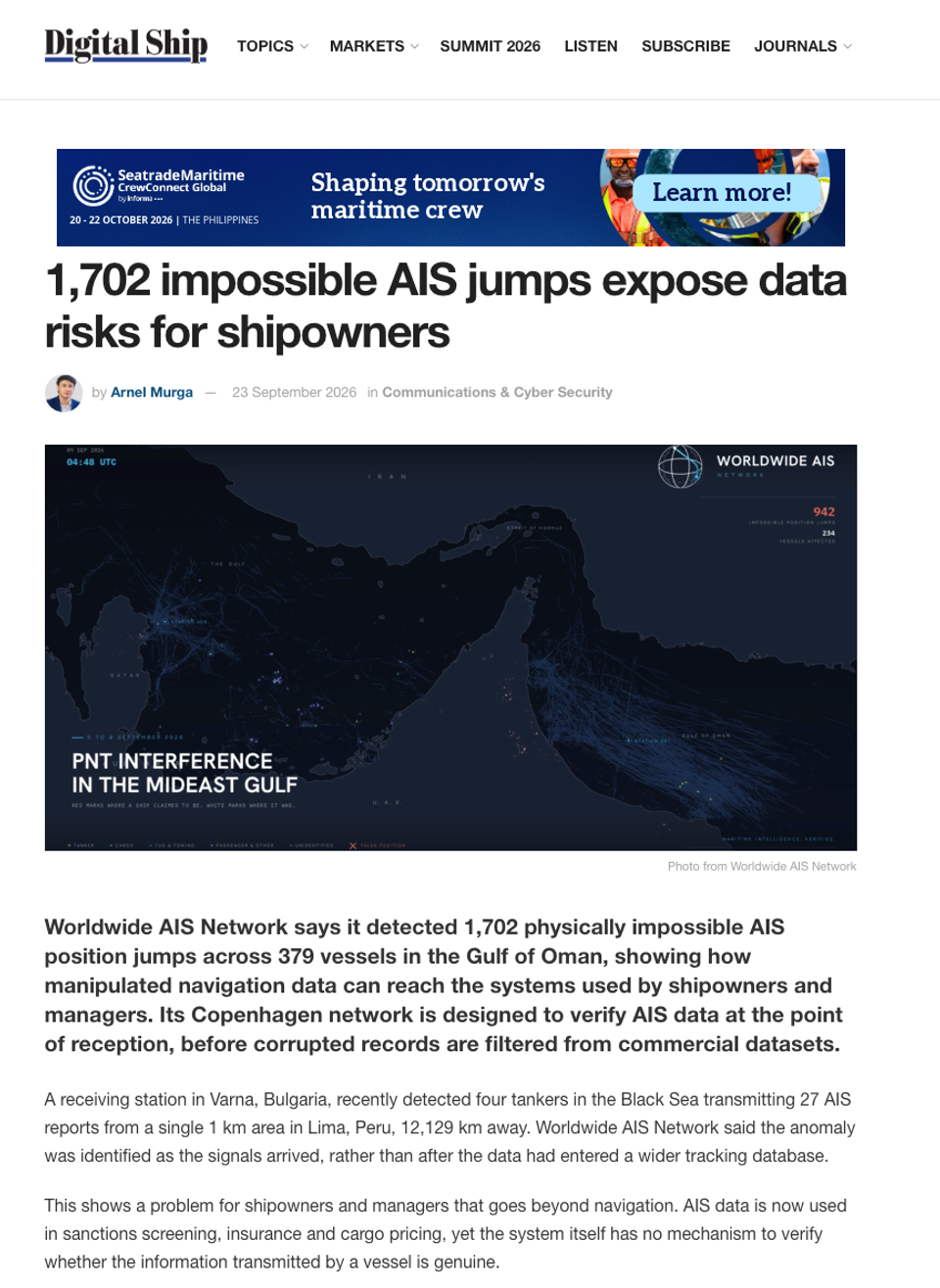
On 10 May 2025 the 304-metre Liberian-flagged container ship MSC Antonia grounded near the Eliza Shoals off Jeddah while sailing from Marsa Bashayer, Sudan [4]. UKMTO had reported electronic interference and GPS disruption across a zone running from Jeddah to Port Sudan the previous day [5]. Windward assessed spoofing as the likely cause, and a subsequent review by Pole Star Global reached the same conclusion [4,6]. Windward's Q1 2025 data put the average reported position jump at 6,300 km, up from 600 km in Q4 2024, with more than 180 vessels affected in the Red Sea in that quarter alone [4]. The operator has not confirmed a cause and it would be wrong to state one as settled. What is not in dispute is that a 304-metre ship went aground in an area with documented interference.
On 17 June 2025 the VLCC Front Eagle collided with the tanker Adalynn roughly 24 nautical miles off the UAE coast near Khor Fakkan. The UAE Ministry of Energy and Infrastructure said preliminary information indicated a navigational misjudgement by one of the vessels, with GPS spoofing clearly evident in the hours before the collision [7]. Frontline described it as a navigational incident unrelated to the regional conflict [8]. Windward's playback showed Front Eagle's AIS track jumping inland into Iran during its approach [9]. The interference is documented. The causal chain is contested.
For a navy or coastguard the relevant cost is not the hull. Own-force units working the same water sit in the same signal environment, and a degraded position picture affects station-keeping, replenishment, boat operations and helicopter recovery long before it affects anything on a chart.
2. Wasted tasking
This is the cost nobody publishes.
Maritime patrol aircraft, cutters, boarding teams and satellite tasking are finite. Each can be spent on a position that was never real. A spoofed track that puts a vessel of interest inside a searchable box burns the same fuel, flight hours and crew rest as a genuine one. The difference only shows up at the end.
The reverse is worse. Between 15 and 18 June 2025, Windward recorded an average of 972 ships per day affected by GNSS interference in the Arabian Gulf and Strait of Hormuz, peaking at 1,155 on a single day, with AIS positions redirected onto land near Asaluyeh and Bandar Abbas in Iran [10]. Over the fortnight following the strikes on Iran, thousands of vessels experienced navigation interference in the Gulf [11]. Screening systems built to flag Iranian port calls did what they were built to do. Compliance and intelligence teams were then buried in false positives, which is a reliable way to lose the real signal underneath.
Mass spoofing does more than create false leads. It creates cover. Deliberate deception sits comfortably inside a background of genuine interference, and the analyst has no cheap way to separate the two.
3. The verification burden
Where the picture cannot be trusted, verification gets done by hand.
The standard method for confirming a vessel is where it claims to be is cross-referencing AIS against satellite radar or optical imagery. It works. It is also slow, expensive, non-continuous and dependent on tasking a sensor that has other jobs.
Androjna and colleagues documented exactly this for tankers moving Russian crude through closed ship-to-ship transfers, identifying falsified positions from repeated discrepancies between claimed AIS locations and Sentinel-1 radar and Sentinel-2 optical imagery. In one case the tanker Turba was broadcasting a position 6 nautical miles from where radar showed it alongside another vessel. In others, tankers reporting positions in the western Black Sea were in fact near the Kerch Strait, some 400 miles northeast [3]. SkyTruth found the same behaviour among tankers concealing calls at Russian Black Sea ports [12].
The same study makes a second point that matters more than the imagery. The falsification was also visible in the reception geometry. Three terrestrial AIS stations near Costanța, all sited at 41 metres or lower, showed apparent reception ranges beyond 450 nautical miles when their realistic range is closer to 40. A vessel appearing 450 nautical miles from a low coastal antenna, seen by no other station in the region, is not 450 nautical miles away. The authors note that confirming this rigorously requires the AIS VHF signal information string carrying time of arrival and received signal strength [3]. That is a measurement taken at the receiver, not a claim carried in the message.
For an enforcement or intelligence organisation, manual verification is a standing analyst tax. A meaningful share of skilled time goes into establishing whether a data point is real before any analysis of what it means can begin. That labour is a hard-dollar floor under the cost of manipulation, and it recurs daily.
4. Enforcement and legal exposure
Sanctions regimes have turned data quality into a liability question rather than a diligence question.
OFAC applies strict liability, and intent is not required for a violation. Its guidance of 31 October 2024, aimed at commodities brokers, insurers, ship management companies, shipbrokers and port authorities, works through scenarios that include spoofing a vessel's location via AIS manipulation to obscure cargo origin, and directs stakeholders to confirm AIS data against trade documentation [13].
On 18 May 2026, Adani Enterprises Limited agreed to pay 275 million dollars to settle 32 apparent violations of the Iranian Transactions and Sanctions Regulations. Between November 2023 and June 2025 the company bought LPG cargoes from a Dubai-based trader that presented them as Omani and Iraqi in origin when they came from Iran, causing US financial institutions to process about 192 million dollars in payments. OFAC listed AIS manipulation among the red flags that should have put the buyer on notice, alongside dark periods, name and flag changes, illogical routing and pricing inconsistent with the claimed origin. The case was classified as egregious and was not voluntarily self-disclosed [14]. The standard being applied is no longer whether an organisation had a documented process. It is whether the warning signs were visible and why nobody acted on them.
For government users the exposure has a different shape and the same logic. Interdiction decisions, designations and diplomatic representations all rest on position evidence. Where that evidence is an unverified self-report, the counterparty gets to argue about the data instead of the conduct.
5. Strategic and escalation cost
The most expensive category is the one with no invoice.
Estimates of the shadow fleet vary with method. Windward has identified roughly 1,100 dark-fleet vessels, while broader counts that include grey tonnage run considerably higher [15]. Whatever the figure, AIS manipulation is core tradecraft for all of it.
Around the Baltic, interference attributed to Russian sources has been persistent. Latvia's Electronic Communications Office recorded 820 cases of satellite signal interference in 2024, against 26 in 2022 [16]. In June 2025 transport ministers from thirteen EU member states put the issue to the Council, citing monthly case counts that rose in Lithuania from 556 in March 2024 to 1,185 in January 2025, and in Latvia from 790 in October 2024 to 1,288 in January 2025 [17,18].
Attribution is now technically tractable. Gattis, Cydejko and Akos deployed four time-difference-of-arrival nodes along the Polish coast of the Gulf of Gdansk, sited on existing RTK reference stations operated by the Maritime Office in Gdynia. Across April to June 2025 they repeatedly localised a circular spoofer and a separate jammer to sites inside Kaliningrad, one solution landing within 50 metres of a suspect antenna array. The emitter was almost 100 km from the furthest node, the hardware was commercial off-the-shelf, and results came back in under five minutes [19]. The method is worth noting: not a better receiver on one platform, but several receivers in surveyed positions comparing when the same signal arrived.
Interference of this kind is grey-zone activity. It is deniable, cheap, sub-threshold and effective. It degrades a coalition's shared picture, complicates attribution of anything that happens inside the degraded area, and creates room to manufacture a factual dispute about where a warship or a merchant vessel actually was. When positional truth is contestable, escalation management gets harder, and the party with less to lose from ambiguity gains.
What reduces the cost
Receiver hardening helps the ship carrying the receiver. Multi-constellation and multi-frequency receivers, controlled reception pattern antennas and inertial coasting all make an own-platform fix harder to falsify. Galileo's Open Service Navigation Message Authentication was declared operational on 24 July 2025, making Galileo the first constellation to offer signal authentication as part of an open service [20]. IALA is clear about the limits: OSNMA improves the ability to detect spoofing, it does not prevent spoofing, and it offers no protection against jamming [21].
None of this tells you whether a third party's broadcast position is true. That is a different problem and it can only be solved off the vessel.
Verifying a third party takes evidence independent of their self-report. Where the transmission physically originated, measured by a network observing the same signal from multiple known points. Whether the reported track is physically possible. Whether the RF characteristics match the claimed transmitter. Whether independent sensing agrees. Worldwide AIS Network exists to produce that evidence. Every message our network receives is captured on hardware with a known, surveyed position and a precise timestamp, signed at the point of reception, so the provenance of a position travels with it instead of being reconstructed afterwards.
The cost of manipulation is not going down. The cost of proving what is real is the variable still under our control.
Frequently asked questions
What is AIS manipulation? Any deliberate falsification of the Automatic Identification System broadcast. It covers spoofing a false position, transmitting a false identity or MMSI, switching the transponder off to go dark, and injecting fabricated tracks. It is distinct from GNSS spoofing, which attacks the vessel's positioning receiver rather than the message, though the two are often used together [3].
How much does AIS manipulation cost? There is no single figure, because the cost is spread across casualties, wasted tasking, analyst time, enforcement exposure and strategic effect. The clearest published anchor is enforcement: OFAC's 275 million dollar settlement with Adani Enterprises in May 2026, in which AIS manipulation featured among the red flags that went unactioned [14].
Can spoofed AIS data be detected? Yes, but not from the message alone. Detection depends on comparing the claimed position against independent evidence: multi-station geolocation of the transmission, physical plausibility of the track, RF characteristics, and corroboration from radar or satellite imagery [3,19].
Does encrypting AIS solve the problem? Not on its own and not retroactively. AIS is a global, mandatory, unencrypted standard carried by more than a hundred thousand vessels under SOLAS Chapter V [1,2]. Changing it would take a decade. Verification at the point of reception can be deployed now, without touching the vessel.
References
- International Maritime Organization. AIS transponders [Internet]. London: IMO [cited 2026 Aug 30]. Available from: https://www.imo.org/en/OurWork/Safety/Pages/AIS.aspx
- UN Trade and Development. Maritime and other transport: data insights [Internet]. Geneva: UNCTADstat [cited 2026 Aug 30]. Available from: https://unctadstat.unctad.org/insights/theme/107
- Androjna A, Pavić I, Gucma L, Vidmar P, Perkovič M. AIS data manipulation in the illicit global oil trade. J Mar Sci Eng. 2024;12(1):6. doi:10.3390/jmse12010006
- gCaptain. GPS spoofing suspected in containership's grounding near Jeddah port [Internet]. 2025 May 13 [cited 2026 Aug 30]. Available from: https://gcaptain.com/gps-spoofing-suspected-in-containerships-grounding-near-jeddah-port/
- Marine Insight. MSC container ship stranded in Red Sea after suspected GPS spoofing [Internet]. 2025 May 14 [cited 2026 Aug 30]. Available from: https://www.marineinsight.com/shipping-news/msc-container-ship-stranded-in-red-sea-after-suspected-gps-spoofing/
- gCaptain. Pole Star confirms GPS interference caused MSC Antonia grounding [Internet]. 2025 May 15 [cited 2026 Aug 30]. Available from: https://gcaptain.com/pole-star-confirms-gps-interference-caused-msc-antonia-grounding/
- Splash247. Oil spill detected from Tuesday's tanker collision in the Gulf of Oman [Internet]. 2025 Jun 19 [cited 2026 Aug 30]. Available from: https://splash247.com/oil-spill-detected-from-tuesdays-tanker-collision-in-the-gulf-of-oman/
- Safety4Sea. Tanker collision in Gulf of Oman unrelated to Israel-Iran conflict [Internet]. 2025 Jun 18 [cited 2026 Aug 30]. Available from: https://safety4sea.com/tanker-collision-in-gulf-of-oman-unrelated-to-israel-iran-conflict/
- Windward. GPS jamming falsely placed VLCC Front Eagle in Iran prior to collision [Internet]. 2025 Jun 18 [cited 2026 Aug 30]. Available from: https://windward.ai/blog/gps-jamming-falsely-placed-front-eagle-in-iran-prior-to-collision/
- Windward. Middle East on the precipice: GPS jamming in the Arabian Gulf and Strait of Hormuz disrupts 970 ships daily [Internet]. 2025 Jun 19 [cited 2026 Aug 30]. Available from: https://windward.ai/blog/middle-east-on-the-precipice-gps-jamming-in-the-arabian-gulf-and-strait-of-hormuz-disrupts-970-ships-daily/
- Scientific American. GPS spoofing is scrambling ships in the Strait of Hormuz [Internet]. 2026 Mar 12 [cited 2026 Aug 30]. Available from: https://www.scientificamerican.com/article/gps-spoofing-is-scrambling-ships-in-the-strait-of-hormuz/
- SkyTruth. Tankers falsify AIS tracking positions to hide entry into Russian Black Sea ports [Internet]. 2023 May [cited 2026 Aug 30]. Available from: https://skytruth.org/2023/05/tankers-falsify-ais-tracking-positions-to-hide-entry-into-russian-black-sea-ports/
- Office of Foreign Assets Control. Sanctions guidance for the maritime shipping industry. OFAC Compliance Communiqué. Washington DC: US Department of the Treasury; 2024 Oct 31. Available from: https://ofac.treasury.gov/media/933556/download
- Office of Foreign Assets Control. Enforcement release: Adani Enterprises Limited settles with OFAC for $275,000,000 related to apparent violations of Iran-related sanctions. Washington DC: US Department of the Treasury; 2026 May 18. Available from: https://ofac.treasury.gov/media/935631/download?inline
- Windward. What is the dark fleet? [Internet]. 2026 Feb [cited 2026 Aug 30]. Available from: https://windward.ai/glossary/what-is-the-dark-fleet/
- Associated Press. What to know about Russia's GPS jamming operation in Europe [Internet]. 2025 Sep 2 [cited 2026 Aug 30]. Available from: https://www.military.com/daily-news/2025/09/02/what-know-about-russias-gps-jamming-operation-europe.html
- Council of the European Union. Call for common actions in response to Global Satellite Navigation Systems (GNSS) jamming and spoofing threats. Doc. 9188/1/25 REV 1. Brussels: General Secretariat of the Council; 2025 Jun 4. Available from: https://data.consilium.europa.eu/doc/document/ST-9188-2025-REV-1/en/pdf
- GPS World. 13 EU member states demand action on GNSS interference [Internet]. 2025 Jun 11 [cited 2026 Aug 30]. Available from: https://www.gpsworld.com/13-eu-member-states-demand-action-on-gnss-interference/
- Gattis B, Cydejko J, Akos D. Baltic sea GNSS jamming and spoofing emitter detection and localization in real-time using a time difference of arrival (TDOA) system. GPS Solut. 2026;30:96. doi:10.1007/s10291-026-02061-5
- European Union Agency for the Space Programme. From testing to operations: Galileo OSNMA service now available to users [Internet]. Prague: EUSPA; 2025 Sep [cited 2026 Aug 30]. Available from: https://www.euspa.europa.eu/newsroom-events/news/testing-operations-galileo-osnma-service-now-available-users
- International Association of Marine Aids to Navigation and Lighthouse Authorities. Open Service Navigation Message Authentication (OSNMA). IALA e-Bulletin [Internet]. 2025 [cited 2026 Aug 30]. Available from: https://www.iala.int/e-bulletin/open-service-navigation-message-authentication-osnma/