What is an AIS Data and Why Is It So Valuable?
- Team WAKE

- Apr 13, 2025
- 11 min read
TL;DR:
AIS (Automatic Identification System) is a global ship-tracking technology that broadcasts vessel location, speed, and identity via radio signals. Originally designed for maritime safety, AIS data is now critical for security, logistics, environmental monitoring, and even finance. Satellite AIS expanded this visibility worldwide—but most data is locked behind expensive platforms. WAKE is building a decentralized AIS network that rewards people for running simple AIS receivers and contributing data. It's open, transparent, and community-powered—giving everyone a chance to help map the world's oceans in real time.
The Lifeline of Modern Maritime Traffic
Every day, thousands of ships silently broadcast their identity, position, and course using the Automatic Identification System (AIS). It's not flashy. It's not futuristic. But it keeps global trade moving and ships safely separated across thousands of miles of ocean.
If you’ve ever tracked a ship online or seen moving dots on a maritime app, you’ve seen AIS in action. But how does it work, and why is the data it produces so valuable? From improving safety at sea to enabling cutting-edge tech like decentralized data networks, AIS plays a bigger role than most people realize.

AIS might not make daily headlines, but it is truly a lifeline of modern maritime traffic. Right now, tens of thousands of vessels – from massive cargo ships to local ferries – are continuously emitting AIS signals. These signals carry critical information: the vessel’s unique ID, its GPS position, heading, speed, status, and more. Nearby ships listen to these broadcasts, as do coastal stations and satellites overhead. The result is a real-time picture of maritime movements across the globe. In the sections below, we’ll break down how AIS works, the many uses of AIS data (and why companies have spent hundreds of millions on it), and how community-driven efforts like WAKE are taking AIS to new frontiers.
What Is AIS and How Does It Work?
AIS is essentially a tracking and communication system for ships. It was developed to enhance safety at sea by automating the exchange of vessel information. An AIS transceiver on a ship uses a standardized VHF radio signal (broadcasting on maritime frequencies 161.975 MHz and 162.025 MHz) to repeatedly send out the ship’s identity and navigation data [3].Think of it as a digital beacon that says “This is who I am and here’s where I am” to the world. Every few seconds, a vessel transmits a short VHF radio message that includes:
Its identity (MMSI, call sign, ship name)
Position (GPS location)
Course and speed
Type of ship and status (e.g., moored, underway)
Importantly, AIS is not just one-way. Ships also receive AIS signals from others in the area, and coastal traffic centers do the same. This allows each participant to build a local traffic picture. In fact, the system was designed by the International Maritime Organization (IMO) as a complementary tool to marine radar for collision avoidance [4]. Since 2004, the IMO has required AIS on virtually all sizable vessels – any ship over 300 gross tons on international voyages, larger cargo ships on domestic routes, and all passenger ships must carry AIS transponders [5]. This mandate means that at any given time, the vast majority of commercial ships are squawking their presence into the ether.
How AIS works in practice: Each AIS-equipped ship has a GPS for accurate positioning and a VHF radio unit that continuously sends out short data bursts (in a time-synchronized format so signals don’t collide). Dynamic data like position, course, and speed are broadcast frequently (every 2 to 10 seconds when moving, up to every 3 minutes if at anchor), while static info like the vessel’s name, call sign, type, and dimensions are sent every 6 minutes. Other ships and stations within VHF range (approximately 40 nautical miles, given the line-of-sight nature of VHF radio) will receive those messages and can plot the ship on a screen [6]. On a ship’s bridge, AIS data usually integrates with electronic chart systems, literally showing other vessels as icons on the map with identifiers and vectors.
This simple concept has profoundly improved situational awareness at sea. Even in poor visibility or radio silence, AIS provides an extra layer of knowledge about who and what is nearby.
Why Automatic Identification System Data Is So Valuable
Originally conceived for safety, AIS data has turned out to be incredibly valuable well beyond its collision-avoidance role. In fact, AIS has been called the oil of the seas – a rich data resource fueling various maritime applications. Let’s break down the key reasons AIS data is prized:
Safety and Collision Avoidance
Safety was the first purpose of AIS, and it remains paramount. By providing real-time tracking of nearby vessels, AIS drastically reduces the risk of collisions. For example, if two ships are on intersecting paths, each can see the other’s identity and course on their AIS display and take action early. AIS is used alongside radar and visual navigation; it even helps identify ships on the radar screen by name. In busy sea lanes or port approaches, this is a lifesaver – literally.
Beyond day-to-day navigation, AIS assists in search and rescue as well. When an incident happens, responders can review AIS records to see what ships were in the area or who might have witnessed a distress call.
Many survival craft are equipped with AIS beacons (AIS-SART) that activate if mariners abandon ship, continuously transmitting their location to aid rescue. All this means AIS data’s value in safety is about protecting lives and vessels. You can’t put a price on that, but it makes AIS indispensable to anyone operating on the water.
Maritime Security and Surveillance
AIS also plays a huge role in maritime security, law enforcement, and even geopolitical analysis. Agencies use AIS data to spot suspicious behavior – for instance, if a cargo ship deviates oddly from its route, slows down in a strange location, or “goes dark” (turns off its AIS), it raises red flags [6]. Such anomalies might indicate illicit activities like unauthorized fishing, smuggling, or sanction evasion by vessels trying to hide. By monitoring AIS tracks, authorities can detect these patterns. In fact, sudden AIS signal loss or irregular routes have been used as evidence of ships conducting ship-to-ship transfers of oil (to dodge embargoes) or entering marine protected areas illegally. AIS provides the identity of the ship, so once suspicious behavior is flagged, investigators know exactly which vessel (and owner) to look into – a task that would be nearly impossible if ships were “anonymous.”
This surveillance aspect makes AIS data very valuable to coast guards, navies, and even financial compliance teams. Banks and insurers, for example, check AIS histories to ensure the ships they finance or cover haven’t been anywhere they shouldn’t be. Accurate vessel identification and tracking is key to maintaining transparency on the seas.
Logistics, Trade, and Operational Efficiency
One of the most lucrative uses of AIS data is in logistics and fleet management. If you manage a fleet of tankers or a port terminal, knowing the real-time locations and ETA of ships is gold. AIS data allows shipping companies and ports to optimize operations – for instance, port authorities use it to coordinate pilotage and berth assignments ahead of a ship’s arrival, and fleet managers track their vessels to adjust voyage plans for weather or delays. “For managers of busy fleets, AIS data provides a valuable source of information on their vessels’ location and activities,” as noted by Lloyd’s List Intelligence [7]. This helps in forward planning – anticipating arrival times, streamlining cargo handling, and reducing idle time. Essentially, AIS data cuts costs by making maritime logistics more predictable and efficient.
The value extends to global trade analysis as well. AIS-based services aggregate ship movements to gauge things like oil supply (tracking tanker routes and storage), commodity flows, and port congestion. In March 2020, the United Nations even used AIS data in its analytics platform to study port traffic efficiency and map fishing activity, aiming to reduce shipping’s carbon footprint. Investors and economists mine historical AIS records to spot trends – for example, how a pandemic or a canal blockage (remember the Suez Canal incident?) impacts global shipping lanes. Historical AIS data is as valuable as real-time; it’s used to identify patterns, build ship traffic heatmaps, and feed machine learning models that predict future movements [8]. The insights from AIS help the industry become smarter and greener, optimizing routes for fuel savings or detecting bottlenecks in supply chains.
Environmental and Research Applications
Beyond commerce, AIS data has big implications for environmental monitoring and scientific research. Conservationists use AIS to track fishing vessel activities and curb illegal fishing in sensitive areas. For instance, the public initiative Global Fishing Watch relies on AIS (plus satellite imagery) to reveal “dark fleets” of fishing vessels operating out of regulations. Marine biologists correlate AIS shipping data with whale migration routes to recommend ship speed limits or route changes that reduce ship-whale collisions. Researchers have used AIS to estimate emissions, study maritime traffic patterns, and even detect anomalies like unexpected slowdown or drifting that could mean a ship in trouble or engaged in clandestine activity.
In port cities, AIS-based analysis can inform infrastructure development (where to build new terminals or improve navigation channels). And let’s not forget hobbyists and citizen scientists: many radio enthusiasts run AIS receivers at home and contribute data to open projects, helping increase the coverage in remote areas. The community aspect of AIS data has grown, which leads us to the latest evolution in AIS usage – the move toward decentralizing its collection.
From Coastlines to Satellites: Global AIS Coverage
One reason AIS data has exploded in value is that it’s no longer confined to line-of-sight range from shore. Initially, a big limitation of AIS was that VHF range of ~40 nautical miles meant open-ocean vessels went untracked by shore stations [9]. For a long time, once a ship sailed far from any coast, its AIS signals disappeared into the void, only seen by nearby ships. That changed in the late 2000s with the advent of Satellite AIS (S-AIS). By placing special AIS receivers on satellites orbiting Earth, companies and agencies extended AIS coverage to practically the entire globe. In 2010, the European Space Agency demonstrated this by installing an AIS receiver on the International Space Station, proving that even from orbit one could pick up those VHF signals. Suddenly, every corner of the oceans could be covered, and truly global ship tracking became possible.

Today, fleets of AIS satellites operated by firms like Spire Global, ORBCOMM, and exactEarth continuously scan for ship signals across the planet. The data volume is immense – on the order of hundreds of millions of AIS messages per day – requiring big data handling and filtering. This global reach is a game-changer: even in mid-ocean, if a ship transmits AIS, someone is likely capturing it. The maritime domain awareness this provides is unprecedented. For example, authorities can track a suspect vessel across oceans, and shipping companies can monitor their assets in real time anywhere on earth.
However, global AIS data collection has largely been the domain of specialized companies and government programs. They invest in satellite launches and vast receiver networks, and in turn often sell the data via subscription services (A large permium being added for S-AIS). This has led to a somewhat centralized and commercialized AIS data market – valuable, but controlled by a few.
A telling example: maritime intelligence firm Kpler acquired not only MarineTraffic (a popular AIS tracking platform) and FleetMon, but also a satellite AIS provider (Spire’s maritime division) in recent years, cementing a data empire. The acquisition of Spire’s AIS data business in late 2024 reportedly cost on the order of $240–250 million [10]. showing just how lucrative AIS data has become. In fact, leaked reports suggested that one major AIS platform’s parent company bragged about monopolizing AIS data and projected revenues of around €200 million in a single year [11]. These figures speak volumes: AIS data is big business.
The Next Frontier: Decentralized AIS Data Networks
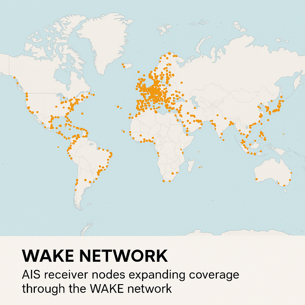
Given the high stakes and centralization in AIS data, a new movement is emerging to decentralize AIS collection and sharing. The idea is simple: instead of data being controlled by a handful of companies, why not empower a community of contributors globally to gather AIS information and make it available as a public resource – and reward them for it? This is where WAKE comes in. WAKE is a visionary project aiming to create a decentralized AIS data network that incentivizes everyday people to run AIS receiver nodes and contribute to a collective global feed of ship positions. In other words, WAKE wants to do for maritime data what some Web3 projects have done for wireless internet or IoT sensors – use blockchain/token incentives to crowdsource a physical network.
Imagine thousands of enthusiasts, port workers, or coastal residents setting up inexpensive AIS receivers (for example, a USB SDR dongle with an antenna) at their location. Each node would pick up AIS broadcasts from ships in their vicinity and relay that data to the WAKE network. Through a blockchain-based system, contributors get rewards (tokens/credits) for providing useful data and validating its accuracy. The more valuable your contribution (e.g. covering a previously dark area of the map, or supplying consistently high-quality data), the more you earn. This creates a positive feedback loop: better coverage and data quality enhances the overall network, attracting more data users, which in turn can drive up the value of the network and rewards. It’s a community-driven model for global AIS collection, aligning the incentives of those who need the data and those who supply it.
There are several reasons why a decentralized AIS network is a big deal. First, it could democratize access to AIS data. Today, if you want comprehensive global AIS information, you typically pay a hefty fee to a provider. With a crowdsourced network like WAKE, the data could be more open or at least far cheaper, because the cost is distributed and offset by token economics instead of traditional subscriptions. Second, it enhances coverage. Volunteers might deploy receivers in nooks and crannies that commercial networks overlook (harbors, remote islands, oil rigs, etc.), filling gaps in existing coverage maps. Third, it adds resilience. A decentralized network has no single point of failure; even if one node goes offline, the data flows from others. And finally, it rewards the community. Rather than big companies profiting off volunteers’ AIS feeds (as has happened historically, where hobbyists fed data to sites that then monetized it heavily [11] ), a blockchain approach shares value back with those contributors. This addresses the fairness issue raised by AIS enthusiasts who realized their free contributions were making companies millions.
It’s worth noting that even industry analysts foresee this shift. A recent AIS market outlook highlighted that “blockchain-secured AIS data networks” and “decentralized AIS data-sharing models” will improve data security and accessibility in the future [12]. The convergence of AIS with Web3 technology is an example of maritime meets crypto in a practical, impactful way. WAKE’s decentralized AIS network isn’t just a theoretical idea; it’s part of a broader trend to leverage decentralized infrastructure for real-world data collection (similar projects in other domains include community networks for weather data, environmental sensors, and of course the famous Helium network for IoT devices).
Getting Involved: Riding the WAKE of Innovation
If the story of AIS inspires you – and especially if you’re excited by the prospect of a community-powered global AIS network – now is a great time to get involved. The beauty of AIS being a radio technology is that anyone can receive it with the right equipment. A basic AIS setup might include an SDR (software-defined radio) dongle or a dedicated AIS receiver, an antenna tuned to VHF, and a simple computer like a Raspberry Pi. With these, you can pick up the signals from ships near you and decode them. Communities like WAKE are making it easier to turn such a setup into a node that feeds a decentralized network. In fact, running a WAKE node could be as straightforward as installing their open-source software and connecting your radio – then watch as ships pop up on your screen and know that you’re contributing to a global dataset (and earning rewards for it). It’s a hobbyist’s dream with a tangible benefit to the world.
Join the WAKE community to learn how to set up your own AIS receiver node and start sharing data. Whether you’re a seasoned radio amateur or completely new to AIS, the community can guide you through the process. By participating, you become part of a movement to keep AIS data accessible and secure for all. You can also follow WAKE on social media for updates on the project’s progress and insights into cool maritime data finds. The ocean has always connected us; with AIS and a decentralized network like WAKE, we can all connect to the ocean in return – one data packet at a time.


Comments